A tropical wave of low atmospheric pressure, on that's been closely watched since last week as it moved west through the Gulf of Mexico toward South Texas, officially became Tropical Depression 9 on Monday afternoon and was expected to bring heavy rainfall to some areas of the Lone Star State.
The Houston area, however, under the strong influence of a heat dome anchored over the Central Plains, will likely not see much relief from tropical downpours.
Texas Hurricane and Tropical Storm Tracker: Keep an eye on tropical storms and hurricanes as they approach the Lone Star State.
What’s the latest?
Areas around and south of Corpus Christi were placed under a tropical storm warning on Monday because tropical storm-force winds are expected somewhere within the region within the next 36 hours, the National Weather Service said. The affected area includes Calhoun, Bee, Jim Wells, Live Oak, Aransas, Nueces, Refugio and San Patricio counties.
As of 4 p.m. Monday, the tropical low was about 500 miles east-southeast of Corpus Christi, moving west at 18 mph with winds of up to 35 mph but showed signs of organizing into something stronger. The National Hurricane Center, which designated the feature Invest 91L on Sunday, said heavy rainfall is expected across South Texas on Tuesday and Wednesday.
“The heavy rainfall may produce areas of flash and urban flooding,” forecasters said in a bulletin Monday. “Across portions of Coahilla and Nuevo Leon in Mexico, flash flooding with possible landslides in mountainous terrain is expected Tuesday into Wednesday.”
The hurricane center also warned that coastal flooding would be possible along the south Texas Gulf Coast on Monday night through Tuesday morning. For the Texas Gulf Coast around and south of Corpus Christi, “tropical storm conditions are expected in the warning area and are possible in the watch area beginning Tuesday morning.”
Satellite imagery found that Invest 91L was producing quite a bit of lightning as it moved over the near-record warm waters of the Gulf of Mexico.

Satellite imagery Sunday afternoon shows Invest 91L moving westward across the Gulf of Mexico. The colored dots you see indicate lightning flash density. Notice the lightning activity on the eastern flank of Invest 91L off the west coast of Florida.
National Oceanic and Atmospheric AdministrationThe tropical system was expected to continue working toward the Texas Gulf Coast. As it does so, some additional strengthening is possible. The consensus among weather models is that the tropical low is most likely to become a tropical depression or low-end tropical storm as it approaches the western Gulf Coast.
What to expect
While winds are likely to become breezy Monday into Tuesday, especially along the Texas Gulf Coast, the more significant impact will be much-needed rain for some.
The rainfall winners along the coast will likely be closer to Corpus Christi, where our potential tropical depression or low-end tropical storm is expected to come ashore Tuesday.
A swath of South Texas, from the coast to the Rio Grande Valley between San Antonio and Laredo could get 1 to 3 inches of rain early Tuesday through Wednesday. Laredo could receive 2 to 3 inches of rain on Tuesday alone, according to the National Weather Service.
Unfortunately for areas along and north of Interstate 10, the chance for meaningful rain just isn’t there. The heat dome, which is anchored over the Central Plains, will pretty much squash any hopes of rain places like Humble and Conroe may have. Areas north of I-10 may see as much as a 20 percent chance for a stray shower or two, leaving most spots rain-free for the foreseeable future. South of Houston, towards League City and Galveston, rain chances will be highest. A 30 to 40 percent chance of rain is expected in coastal areas of Southeast Texas, where onshore wind gusts of up to 30 mph could make rain wind-whipped.

Beneficial rains become less likely north of Interstate 10 through Tuesday. Areas of extreme drought are not likely to see much improvement over the next five days.
WeatherBELL
Winds could become breezy across Southeast Texas ion Monday into Tuesday. This will keep the wildfire risk high despite the arrival of tropical moisture through Tuesday.
WeatherBELLWhat’s changed from last week?
Think back to last week’s forecasts. The first mention of anything brewing in the Gulf of Mexico occurred on Aug. 16. At the time, we had a nearly equal chance that whatever developed in the Gulf of Mexico would track east of Houston, over Houston, or south of Houston. By last Friday, trends became increasingly skeptical of a track over Houston. Both European and American forecast models came into agreement over the weekend that whatever approaches the Texas Gulf Coast will do so well south of Houston.
WEATHER: Here’s what we know so far about the rain-making tropical low heading toward Texas this week
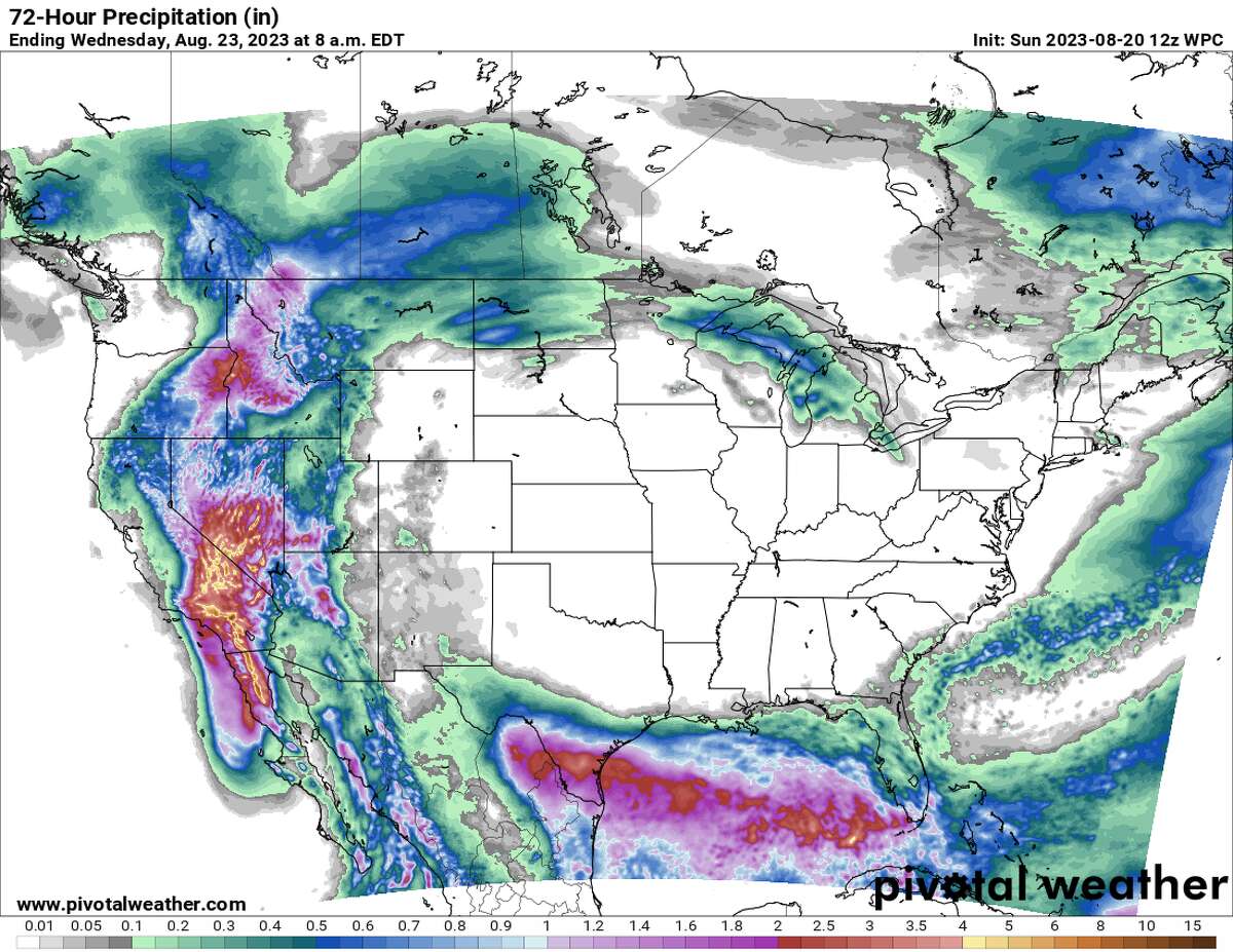
Rain over the next three days will remain mostly absent from the forecast near and north of Houston thanks to the ongoing influence of the heat dome.
Weather Prediction Center / Pivotal Weather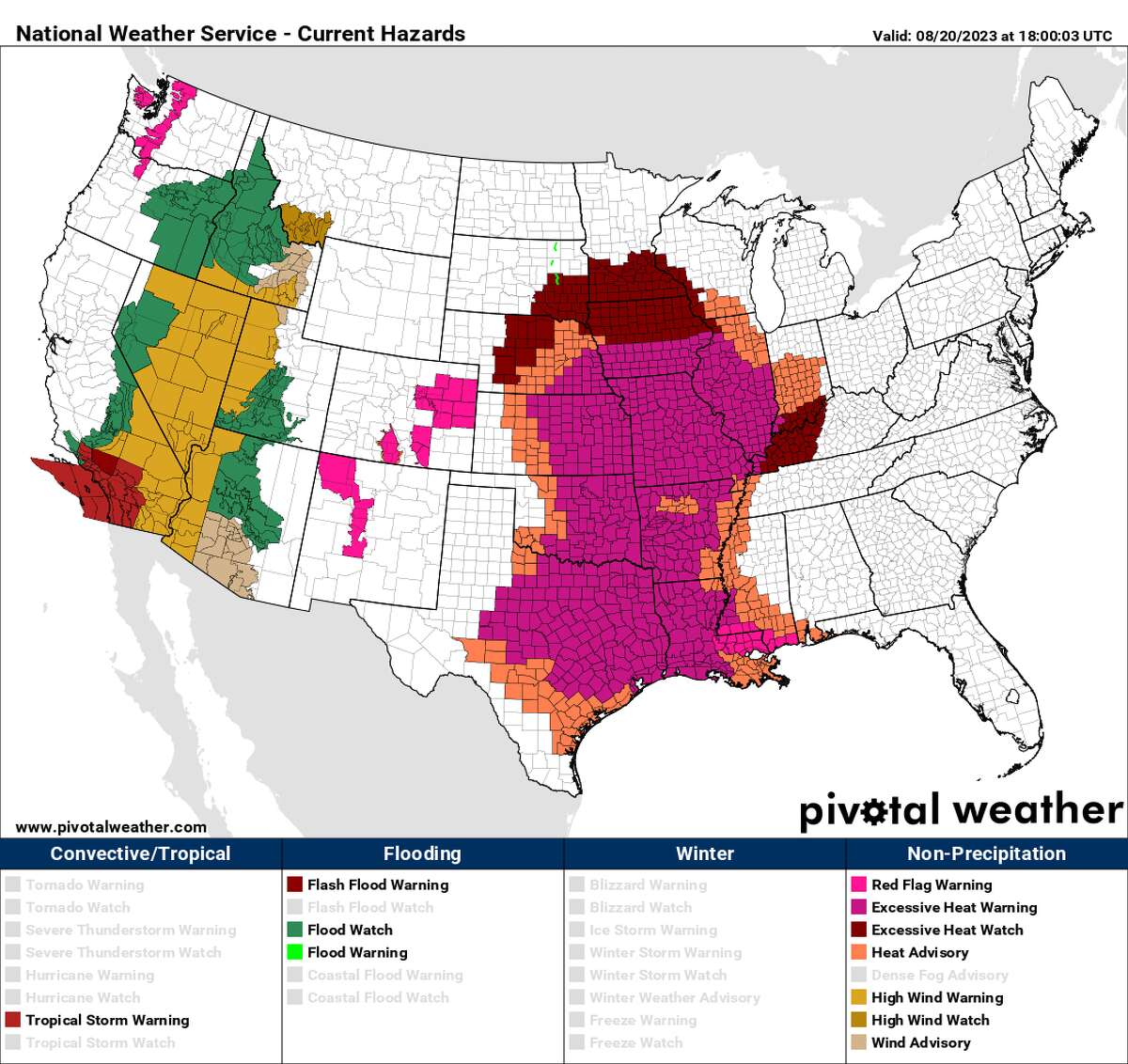
Numerous heat alerts were in place from Minnesota to Texas on Sunday.
National Weather Service / Pivotal WeatherWhat prompted the southern track? For that, we have to look at the heat dome, which has been a consistent part of our forecast since June. The ridge of high pressure above our heads is anchored over the Central Plains. You can see the influence of the heat dome by looking at the sheer number of heat alerts that stretch from Minnesota to Texas. The heat dome’s hand in our forecast can be made even more apparent when looking at three-day rainfall totals. The “donut hole” in the middle of the country is not just where the hottest temperatures are expected over the next seven days, but also the driest weather will be through midweek.
"low" - Google News
August 21, 2023 at 09:09PM
https://ift.tt/WCSJds0
How Gulf Coast tropical low-pressure system impacts Houston weather - Houston Chronicle
"low" - Google News
https://ift.tt/i5yeaok
Bagikan Berita Ini


0 Response to "How Gulf Coast tropical low-pressure system impacts Houston weather - Houston Chronicle"
Post a Comment