ROCHESTER, Minn. (KTTC) – This winter we have had over 60 days where low temperatures are warmer than normal. That’s almost 80 percent of the entire season. This event did not start this winter but can go as far back as mid-summer. The warm lows this winter are the combination of the strong El Nino and everyday weather. Minnesota Department of Natural Resources Climatologist Pete Boulay said this winter is quite unusual.
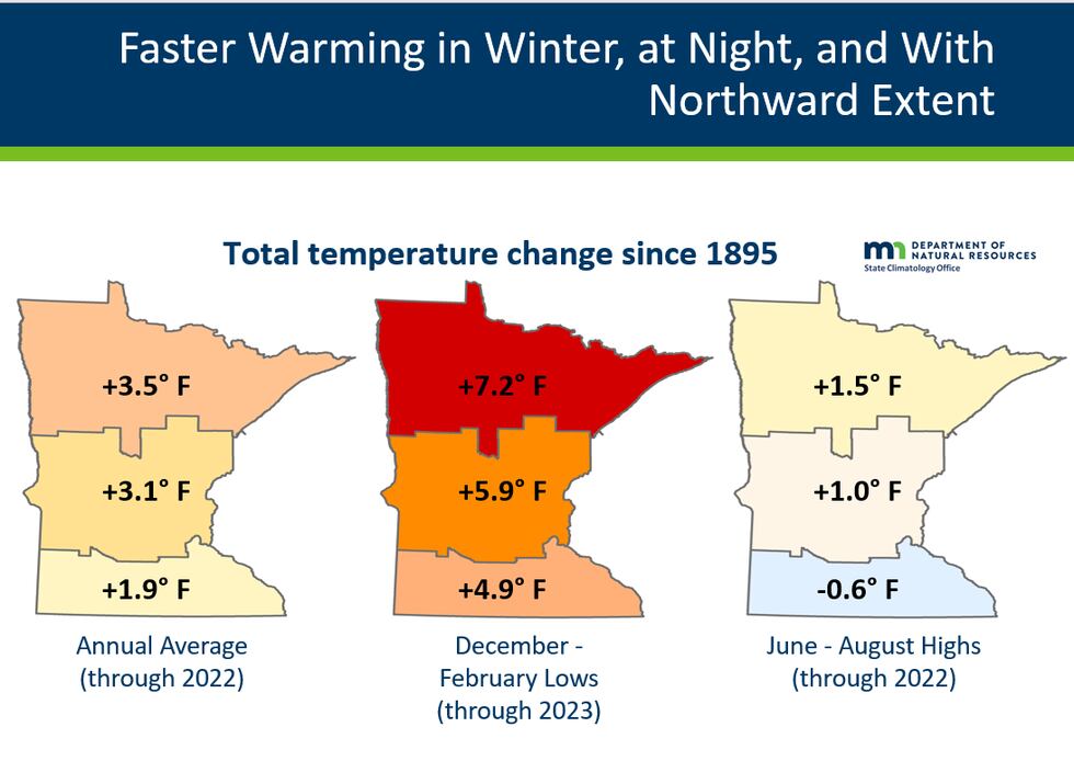
“On any meteorological scale we have never had a winter quite like this, “Boulay said. “If you look at overnight minimum temperatures, from December to February, the low temperatures are up almost five degrees,” he said.
The five-degree uptick is across is across southern Minnesota since 1895, while annual averages are almost two degrees warmer. This winter multiple records have been broken for highs and warm lows in Rochester.

“In Rochester we had 50 degrees ten times since December, and broke six record highs and five record warm lows,” Boulay said.
The warm low temperatures can also be attributed to the lack of snowfall this season. When it snows, it acts as a blanket keeping warm air in the ground and provides cooling at the surface, without it, lows are warmer.
“A good chunk of that is the snow cover, we can’t keep the snow cover around like we used to,” Boulay said. National Weather Service (NWS) Meteorologist Jeff Boyne said a snowpack and cloud coverage can help lower temperatures.
“Temperatures in the soil are not able to infiltrate the air, so the air near the ground continues to cool because of that snow,” Boyne said. “Those clouds can act as an insulting blanket over top of us and that also helps keep us warmer at night,” he said.
Another contributing factor to warmer temperatures across the seasons and at night is based on another trend that the state is progressively getting more wet.
“Overall, we are getting wetter in the state 2019 is the wettest year on record, we have more moisture around, overnight minimum temperatures that is one sign of it,” Boulay said.
Dewpoints measure the temperature at which saturation happens at and if conditions are moist near the surface temperatures will be warmer. This is apparent for overnight lows with vegetation and droughts.
“If we don’t moisten our topsoils up and our vegetation isn’t growing at the time that will tend to lower our dewpoints at night, which will allow our temperatures to cool at nighttime,” Boyne said.
This summer and spring will serve as a detrimental point because if another drought happens lows may continue to trend warmer than normal.
Also, December is the second warmest for Minnesota at 24.7 degrees, which is 11.1 degrees above normal. The warmest winter on record was set in 1930-1931 with at an average temperature of 26.3 degrees for Rochester.
Find stories like this and more, in our apps.
Copyright 2024 KTTC. All rights reserved.
"low" - Google News
February 17, 2024 at 08:40AM
https://ift.tt/9k36tqL
Low temperatures trending warmer since midsummer - KTTC
"low" - Google News
https://ift.tt/J7iMGEc
Bagikan Berita Ini


0 Response to "Low temperatures trending warmer since midsummer - KTTC"
Post a Comment