5:30 p.m.
The National Weather Service shared an image of the spinning area of low pressure over the Pacific Ocean on Tuesday afternoon. The system sent rain and snow to California on Tuesday, and more precipitation is expected through Wednesday as it continues to move slowly southward along the California coast.
"Impressive low pressure off the NW California as seen on latest visible #satellite loop," the weather service said in a tweet posted at 4:50 p.m. "This low is forecast to fill (weaken) and move south over the next couple of days. Expect showers to continue into Wednesday (with a few thunderstorms tonight)."
Interstate 80 closed after multiple spinouts
4:04 p.m.
Westbound Interstate 80 at the Nevada state line and eastbound I-80 in Colfax are closed, the California Highway Patrol announced on Twitter on Tuesday.
The closures were prompted by multiple vehicle spinouts, the CHP said. There is no estimate for when the freeway will open.
Police remind drivers to slow down after car flies off interpass
3:22 p.m.
As the latest storm drenches the Bay Area on Tuesday afternoon, police in Benicia took to Twitter to remind drivers to slow down after a vehicle "flew off the Interstate 780 overpass."
The vehicle landed on East Fifth Street in Benicia after driving off the overpass, police said. No injuries were reported, and the area was closed.
Snow falls across Lake County

A view of current snowfall in Clear Lake, Calif., on Tuesday, March 28, 2023.
Twitter user Chloe in Clear Lake1:45 p.m.
Just north of the San Francisco Bay Area, the hills of Lake County were covered in snow as a strong storm system spun off the West Coast and sent a cold front to Northern California.

Snowy conditions on Route 29, near Kelseyville in Lake County, Calif., on Tuesday, March 28, 2023.
Caltrans District 1"It's snowing pretty hard in Lake County right now," ABC7 meteorologist Drew Tuma posted on Twitter just before noon.
The National Weather Service issued a winter weather advisory for Lake County on Tuesday with 2 to 7 inches of snow possible.
Weather service forecaster Josh Wood said at 1:30 p.m. that there were lots of reports of snow piling up in the mountains of Lake County as well as a report of snow falling but not sticking around Clear Lake.
A Twitter user shared an image of Clear Lake and the surrounding mountains frosted in snow. "Springtime snow in lovely Lake County after Tuesday's unusual storm front blanketed Mt. Konocti, Cobb Mt. and many parts of Northern California," the tweet read.

A view of current snowfall in Clear Lake, Calif., on Tuesday, March 28, 2023.
Twitter user Chloe in Clear Lake“It’s a very strong system and it’s unusual to get totals like this entering into spring," Wood, who works for the Eureka office, told SFGATE over the phone. "It’s driven by the strength of a surface low coming down from the north. It’s more of a wintertime setup.”
To the south of Lake County, snow was also falling on the highest peaks in the Napa Area, including on Howell Mountain.
The weather service's Bay Area office said on Tuesday afternoon that the cold air mass over the region was cold enough to support snow at higher elevations in Napa and Sonoma counties.
The weather service said at 12:20 p.m. on Twitter that the temperature atop Mount St. Helena was 27 degrees.
Hail and waterspout warnings expire in SF Bay Area

A pedestrian walks down California Street during a rainstorm in San Francisco on March 28, 2023.
Douglas Zimmerman/SFGATE1:15 p.m.
Special weather statements from the National Weather Service warning of hail and powerful winds over parts of the Bay Area and waterspouts over San Francisco Bay expired at 1 p.m.
Weather service forecaster Sarah McCorkle said just before 1 p.m. that the heaviest rain was mostly over for the San Francisco Bay Area for now, but the East Bay could potentially see some more heavy showers this afternoon. While the weather service had warned hail storms may occur this afternoon, McCorkle said she had not heard of any actual hail developing.
Another round of rain is expected to impact the Bay Area late Tuesday night into Wednesday morning.
“We have more confidence tonight into tomorrow morning that we could see some hail because we have a colder air mass moving in,” McCorkle said.
Weather service issues waterspout warning for San Francisco Bay
12:25 p.m.
The National Weather Service issued a special marine warning just before noon on Tuesday stating that waterspouts, dangerous winds and pea-size hail are possible over San Francisco Bay, including the area south of the Bay Bridge. The warning is in effect through 12:45 p.m.
Weather services warns of hail storms
12:20 p.m.
The National Weather Service issued a special weather statement just after noon on Tuesday warning of 50 mph winds and pea-size hail through 1 p.m. in Oakland, Hayward and San Mateo.
"Seek shelter in a sturdy structure," the agency said.
Two lanes blocked on southbound I-280 in South San Francisco
11 a.m.
A fallen tree closed the right and center lanes on southbound Interstate 280 at Avalon Drive in South San Francisco, 511 SF Bay Area reported.
KCBS Radio reported that traffic was backed up and that the lanes are expected to be reopened by noon.
More flood advisories issued for SF Bay Area
10:45 a.m.
The National Weather Service's Bay Area office issued a smattering of flood advisories for areas across the region on Tuesday morning as a cold front bore down on Northern California.
These advisories are sounding the alarm bells that minor flooding in low-lying areas such as roadways is possible. Small rises on creeks and streams could also occur.
The advisories are in effect for portions of southern Sonoma and northern Marin counties, northern Sonoma County, southern Marin and far northern Sonoma counties, northern Napa county, San Francisco and the Peninsula and the East Bay.
You can find the latest advisories on the agency's Twitter account.
Flights delayed at San Francisco airport due to California storm
10:10 a.m.
Departing flights at San Francisco International Airport were seeing delays up to 50 minutes on average Tuesday due to wind, the Federal Aviation Administration said in a report posted at 8:30 a.m.
Flood advisory issued for San Francisco and Peninsula
9:30 a.m.
The National Weather Service issued a flood advisory for San Francisco and parts of the Peninsula as a cold front dumped rain over the Bay Area on Tuesday morning.
The advisory is in effect through 12:30 p.m. Tuesday, with minor flooding on highways, streets and underpasses expected. Rises on streams are also possible.
"Turn around, don't drown," the weather service warned.
San Francisco, Daly City, San Mateo, South San Francisco, San Bruno, Pacifica, Burlingame, Millbrae, Hillsborough, Brisbane, Colma, Broadmoor, Montara and Moss Beach are all included in the warning.
Get more information from the weather service.
National Weather Services extends flood advisory for North Bay as California storm hits
8:30 a.m.
The National Weather Service extended a flood advisory for parts of the North Bay from 8:45 a.m. to 10:45 a.m.
Minor flooding is expected in “low-lying and poor drainage areas,” the weather service said.
Get more information from the weather service.
Northbound I-5 near Redding closes due to ‘whiteout conditions’
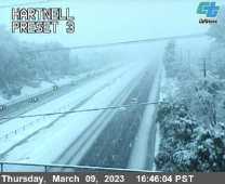
FILE - Snow fell on Interstate 5 near Redding on March 9, 2023.
Caltrans8:15 a.m.
Caltrans announced just after 7 a.m. that northbound Interstate 5 was “closed to all traffic at Fawndale, 10 miles north of Redding, due to whiteout conditions.”
Find updates from Caltrans’ website and Twitter account.
Flood advisory issued for North Bay
7:30 a.m.
The National Weather Service issued a flood advisory for a large portion of the North Bay early Tuesday as a storm bears down upon the Bay Area.
Urban and small stream flooding caused by excessive rainfall are expected. The flood advisory is in effect through 8:45 a.m.
Line of moderate showers pass over Marin County
7:15 a.m.
The National Weather Service's Bay Area office shared radar imagery on Twitter showing a line of showers passing over Marin at about 7 a.m.
Weather service meteorologist Rick Canepa told SFGATE at 7 a.m. that some locations in the North Bay had already picked up 0.5 inch of rain.
National Weather Service posts video about the Bay Area storm

FILE - A pedestrian uses an umbrella as a shield from high winds and rainfall during a storm in Oakland, Calif., on March 21, 2023.
Douglas Zimmerman/SFGATE7 a.m.
The National Weather Service posted a video on Twitter sharing the details of the storm bearing down on the Bay Area. It's expected to deliver a one-two punch of wind and rain across Tuesday and Wednesday.
More Storm Coverage
"low" - Google News
March 29, 2023 at 07:52AM
https://ift.tt/tAwoldB
Storm updates: See the 'impressive' area of low pressure off California coast - SFGATE
"low" - Google News
https://ift.tt/KjQn0Bv
Bagikan Berita Ini


0 Response to "Storm updates: See the 'impressive' area of low pressure off California coast - SFGATE"
Post a Comment