Lake Powell on the Colorado River fell to its lowest level on record last week, highlighting long-term risks to the reservoir that stores water for delivery to Lake Mead and to Arizona, California and Nevada.
But on a brighter note, a good snowpack season has boosted the latest forecast for Lake Powell to a level not reached in more than two years. The predicted increase will not, however, bring anywhere near enough water to completely reverse declines in the lake's water levels stretching back to 2000.
The lake fell to 3,522.16 feet on Monday afternoon. That broke its previous record low of 3,522.24 feet on April 22, 2022. Records date back to the 1960s when Powell started filling after its creation by construction of Glen Canyon Dam.
Powell, at the Arizona-Utah border, kept dropping last week to 3,521.95 feet Friday afternoon. The lake will drop to as low as 3,520 feet at the end of March before the arrival of spring-summer runoff from melted snows starts to bring the level back up again, federal forecasts predict.
People are also reading…
The decline in the past year was expected but is much less severe and will last for a much shorter duration than declines at Powell in the last couple of years, due to federal "drought response actions," said U.S. Bureau of Reclamation spokeswoman Becki Bryant. Those actions included holding back a significant amount of water last year that was scheduled to be released downstream to Lake Mead, and releasing extra water into Powell from Flaming Gorge Reservoir upstream at the Utah-Wyoming border.
Still, Lake Powell has now declined almost 180 feet since hitting a nearly full elevation of 3,697 feet in July 1998. Since 2000, annual Colorado River flows dropped by nearly 20% from 20th century levels due to increasingly arid weather. Mead's level has also plunged in that time, from being nearly full, which would be 1,200 feet, to 1,047 feet Friday evening.
Climate change in the form of continued warming weather has played a major role in the river and lakes' declines, several studies show.
The declines have been severe enough that the Bureau of Reclamation and the seven river basin states, including Arizona, are locked in still-unsuccessful negotiations over how to cut use of river water.
Officials say they're concerned that without dramatic cuts in river water use, Powell could soon drop below 3,490 feet, the minimum level at which its turbines can generate electricity. They're also concerned that if the decline persists beyond that, it could fall to "dead pool" at 3,370 feet — the point at which water can't pass through the dam into the Colorado River downstream.
But the most recent forecasts suggest the river and lakes could be in for a short-term reprieve.
Federal Colorado Basin River Forecast Center predictions, released last week, say Powell should receive 117% of its average April through July runoff this year. The most recent Bureau of Reclamation monthly forecast predicts Powell most likely will rise to 3,564 feet by the end of July before falling again.
The reason for the positive forecasts is unusually heavy snowfall in the Upper Colorado River Basin states of Colorado, New Mexico, Utah and Wyoming in December 2022 and January 2023. While the first half of February was unusually dry, the Upper Basin's snowpack levels still range from 95% to 175% of normal, the forecast center said.
Over the next week to 10 days, forecasters say, the rains and snows that marked the early periods of winter should resume, meaning there will be below average temperatures and above normal precipitation — which would boost river and lake levels more.
As recently as December 2022, federal forecasts found it was possible although not likely that Powell would fall below 3,490 feet for much of 2024. But now, even the bureau's most recent "minimum probable" forecast covering the next two years doesn't show Powell falling below 3,512 feet by January 2025. That "minimum probable" forecast predicts the reservoir level that's lower than 90% of all possible levels.
While these forecasts are positive, "I think people should be reminded, in the last 23 years, we had some big years" in 2005, 2011, 2017 and 2019, said Eric Kuhn, a water researcher and author and former general manager of the Colorado Water Conservation District in Glenwood Springs.
But "we’ve had more dry years than we’ve had big years. What we’re seeing is not unusual. Wet years are part of our overall pattern. We haven't had enough of them," Kuhn said.
This year's wetter weather isn't a reason to pull back on the water conservation measures now being discussed, said Kuhn, adding, "Not one bit, no."
If one assumes that the 21st century average of river water uses and losses, including water delivered to Mexico, isn't reduced, it would take 6 to 7 years of runoff like the river had in 2011 — the biggest runoff year of the 21st century — to refill both Lakes Powell and Mead, said Jack Schmidt, director of Utah State University's Colorado River Research Center.
Recovery of both lakes could be achieved more quickly if the states reduce their water use and their water losses to forces such as evaporation, he said.
A study published by the center in 2022 estimated that if runoff continues to match what's occurred since 2000, Powell and Mead will average about 50% full over the long term. Powell today is 23% full and Mead is 29% full, after river flows fell well below their 21st century average starting in 2018.
"We aren’t ever going to get 6-7 years like this one back-to-back-to-back," Schmidt said.
Sarah Porter, director of the Kyl Center for Water Policy at Arizona State University, said she's had several conversations with people who closely follow the river's ups and downs. They have said they hope one good winter won't cause people "to kick the can down the road" when it comes to cutting water use.
"We keep getting into this danger zone. We need to find permanent solutions to stay out of the danger zone," Porter said.
As water in one of the nation's largest reservoirs recedes, geologic features hidden for nearly 50 years are revealed in Glen Canyon National Recreation Area in Northern Arizona. Video courtesy of Glen Canyon Institute, 2022
Photos: The receding waters of Lake Powell, Glen Canyon National Recreation Area

Tom Wright hikes past the beached marker for Willow Canyon where it joins with the Escalante River, Glen Canyon National Recreation Area, Utah.

A big horn sheep stands with the moon as a backdrop, looking over Fiftymile Creek, Glen Canyon National Recreation Area, Utah.

Tom Wright walks through the shaft of light peeking through the narrow openings of the formation called the Subway in Fiftymile Creek, accessible since the waters of Lake Powell have fallen dramatically.

A narrow sliver of sky is visible overhead through the narrow opening of the formation called the Subway, Fiftymile Creek, accessible since the waters of Lake Powell have fallen dramatically.

The dark streaking, called Desert Varnish, is from the seepage of oxidation in the rocks, and is beginning to erase the "bathtub ring", the lighter colored marks left by the waters of Lake Powell on canyon walls, Fiftymile Creek, Glen Canyon National Recreation Area, Utah.

The remains of a small boat, underwater for years, reemerges due to receding water levels of Lake Powell in the Glen Canyon National Recreation Area, Utah.
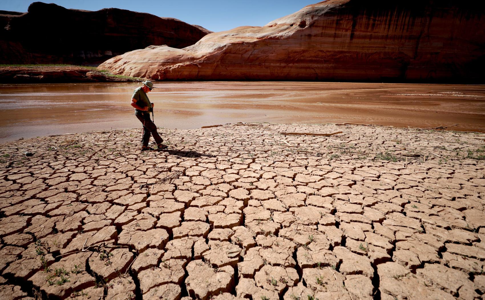
Frank Colver makes his way over the dried and cracking silt left where the Escalante River joins Lake Powell, Glen Canyon National Recreation Area, Utah. The receding water of the lake has the river cutting through the decades of accumulated silt to form a delta where it meets the lake.

A warning buoy sits high and dry far from the end of the closed public boat ramp at Bullfrog Bay, Glen Canyon National Recreation Area.

A line of tires that were once breakwaters at Bullfrog Bay Marina are now stranded on the rocky landscape high above the current water levels at the Glen Canyon National Recreation Area, Utah.

A pedestrian ramp lies well above the water levels at Bullfrog Bay in the Glen Canyon National Recreation Area, Utah.

A stranded wakeless zone buoy sits on the cracking silt outside the new shores of the Bullfrog Bay Marina, Glen Canyon National Recreation Area, Utah.

The end of the ferry ramp ends well short of the new water levels of Bullfrog Bay on the Glen Canyon National Recreation Area, Utah.

An early riser watches the sun come over the low waters of Bullfrog Bay Marina, Glen Canyon National Recreation Aria, Utah. The lighter colored areas on the canyon wall mark previous water levels.

A group of river rafters drift west on the current of the San Juan River outside Mexican Hat. The San Juan feeds Lake Powell.

The tops of a few cottonwood trees begin to poke out of shrunken water of Lake Powell, Fiftymile Creek, Glen Canyon National Recreation Area, Utah.

The remaining large water craft and house boats are crowded together in one of the last areas of water deep enough to support them at Wahweap Mariana, Glen Canyon National Recreation Area, Page, Ariz.

The waters of Lake Powell are twenty to thirty feet below the end of the public boat ramp at Wahweap Mariana, Glen Canyon National Recreation Area, Page, Ariz. Personal non-powered craft still use the ramp to unload, but must be carried up and down the banks to reach the water.

A view north from the Wahweap Marina Overlook show the shrunken waters around the marina in Glen Canyon National Recreation Area, Page, Ariz.

The underside of Gregory Natural Bridge, passable for the first time in almost 50 years, over the Fiftymile Creek, Glen Canyon National Recreation Area, Utah.

The moon rises over Gregory Natural Bridge, passable for the first time in almost 50 years, over the Fiftymile Creek, Glen Canyon National Recreation Area, Utah.

The exposed penstocks (intakes to the power turbines) on Glen Canyon Dam in the Glen Canyon National Recreation Area, Page, Ariz. The water level is at its lowest since 1967, when the dam was still being initially filled.

A group of sightseers get a look at the Glen Canyon Dam during a boat tour of Lake Powell, Glen Canyon National Recreation Area, Page, Ariz.

A small fishing boat ties up on the breakwater just outside the intakes for the Glen Canyon Dam, Glen Canyon National Recreation Area, Page, Ariz.. The penstocks (water intakes to the power turbines) are revealed for the first time since 1967 when the Lake Powell was being filled.

Swimmers and bathers use the jagged shores of the newly exposed banks of Lake Powell just above the Glen Canyon Dam, Glen Canyon National Recreation Area, Page, Ariz.

The Glen Canyon Bridge lies in front of electrical towers with feeder lines rising from the hydroelectric plant in the Glen Canyon Dam, Page, Ariz.

Glen Canyon Dam from Glen Canyon Bridge, Page, Ariz.

Small power boats on the Colorado River head upstream just below the Glen Canyon Dam, Page, Ariz.

Wade Quilter walks through the remains of cottonwood and Russian olive trees washed down and joined with silt to form a natural dam where Willow Canyon joins with the Escalante River, Glen Canyon National Recreation Area, Utah,

The remains of a big mouth bass lay in the silt just above where the Escalante River joins Lake Powell, Glen Canyon National Recreation Area, Utah.

The formation known as The Cathedral in the Desert on Clear Creek, Glen Canyon National Recreation Area, Utah. The re-emergence of the formation is drawing sightseers after being submerged for some 50 years.

Tom Wright feels the water oozing from the rocks in the formation known as Cathedral in the Desert on Clear Creek, Glen Canyon National Recreation Area, Utah. The re-emergence of the formation is drawing sightseers after being submerged for some 50 years.

Frank Colver takes a quiet moment and plays a handmade flute near the waterfall in the formation known as Cathedral in the Desert on Clear Creek, Glen Canyon National Recreation Area, Utah. The re-emergence of the formation is drawing sightseers after being submerged for some 50 years.

Jake Quilter walks down the newly cut banks of Clear Creek just outside Cathedral in the Desert, Glen Canyon National Recreation Area Utah. The sand is silt left behind by the receding waters of Lake Powell.

The tops of cottonwood trees that used to be under a hundred feet of water in Lake Powell are visible again in Clear Creek, Glen Canyon National Recreation Area, Utah. The deep water preserved the remains of the trees.

Boaters have to zig-zag through the rocks emerging due to receding waters of Lake Powell, Glen Canyon National Recreation Area, Page, Ariz.

Several images combined for a panoramic view of the Colorado River where it runs through the what once was Hite Marina in the Glen Canyon National Recreation Area, Utah.

A couple of sightseers take in the view from Hite Overlook over the Colorado River and the closed Hite Marina, Glen Canyon National Recreation Area, Utah.

Lone Rock, jutting out of the dry bed, would usually be surrounded by Lake Powell but is now well clear of the water, Glen Canyon National Recreation Area, Utah.

Tires that used to hold the lines well below the surface of Lake Powell are suspended over the water at Antelope Point Marina, Ariz.

Sightseers twenty or thirty feet above get photos of the low water levels of Lake Powell from the public boat ramp at Antelope Point Marina, Ariz.

The pedestrian access ramp ends abruptly twenty feet over the new Lake Powell surface at Antelope Point Marina, Ariz.

The entrance to the pedestrian access ramp of the Antelope Point Marina is taped off after being cutoff from the docks due to receding waters of Lake Powell.
Contact Tony Davis at 520-349-0350 or tdavis@tucson.com. Follow Davis on Twitter@tonydavis987.
"low" - Google News
February 19, 2023 at 06:05AM
https://ift.tt/qyVrEel
Lake Powell hits record low but snowy weather should bring reprieve - Arizona Daily Star
"low" - Google News
https://ift.tt/EV3utLZ
Bagikan Berita Ini


0 Response to "Lake Powell hits record low but snowy weather should bring reprieve - Arizona Daily Star"
Post a Comment