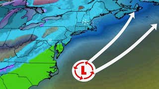
- A low-pressure system will track off the East Coast this weekend.
- This system could bring snow and rain to the East.
- The forecast track of this system is still highly uncertain.
A potential coastal storm could impact parts of the East with snow and rain this weekend, including areas that were hammered by Winter Storm Orlena earlier in the week.
However, we do not anticipate a repeat of Orlena, neither in how long it lasted nor how much snow it dumped.
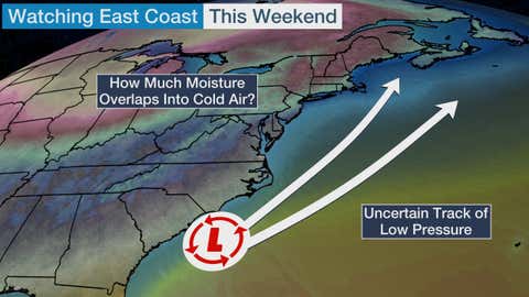
What we are watching for this weekend is a low-pressure system forecast to develop near the Southeast coast late Saturday. This will be in response to a jet stream disturbance moving toward the East.
That low will then track northeastward near or well off the East Coast through Sunday night. What's uncertain for pinpointing specific impacts in the mid-Atlantic and Northeast this far out is how close that low will track in relation to the coast.
Here are a few general forecast scenarios:
1. A track of the low just offshore would wrap more moisture into the mid-Atlantic and Northeast, resulting in a greater threat of snow and rain, or a mix of both, in parts of the region.
2. If the low tracks somewhat farther offshore, then those regions might see a glancing blow from this storm, with some snowfall possible.
3. There would be little or no impact from this system if the low tracks well off the East Coast.
Right now, most of the computer model guidance is depicting Scenario No. 2 as the most likely outcome, with a light to moderate snowfall, at most. But this forecast is highly uncertain, and we cannot rule out a bigger impact.
For now, here's what our forecast shows for this weekend. Keep in mind that changes are highly likely and you should check back frequently for updates.
Weekend Outlook
Saturday into Saturday night, this potential weather system will still be in its formative stages. That means the jet stream disturbance involved in this setup could bring light snow to parts of the Midwest.
At the same time, the developing low-pressure system might bring rain to the Southeast. This precipitation could fall as snow in portions of the southern and central Appalachians.

Saturday Night's Forecast
Sunday is when this system would bring the majority of its impacts to the mid-Atlantic and Northeast.
It's possible that parts of the Interstate 95 corridor see snow or a mix of rain and snow from Washington D.C. to Maine. Light snow might also fall across the interior Northeast as the previously mentioned jet stream disturbance moves through.
There is the potential for accumulating snow in some areas, but it's too early to provide a specific forecast. That's due to the very uncertain track of the low-pressure system discussed earlier.
One thing to note is that this system will be a fast-mover, and that will limit its ability to bring long-lasting impacts.

Sunday's Forecast
The Weather Company’s primary journalistic mission is to report on breaking weather news, the environment and the importance of science to our lives. This story does not necessarily represent the position of our parent company, IBM.
"low" - Google News
February 05, 2021 at 04:22AM
https://ift.tt/2YIZBXp
Weekend Coastal Low Could Bring More Snow to Northeast, but Nothing Like Winter Storm Orlena | The Weather Channel - Articles from The Weather Channel | weather.com - The Weather Channel
"low" - Google News
https://ift.tt/2z1WHDx
Bagikan Berita Ini


0 Response to "Weekend Coastal Low Could Bring More Snow to Northeast, but Nothing Like Winter Storm Orlena | The Weather Channel - Articles from The Weather Channel | weather.com - The Weather Channel"
Post a Comment