Jacksonville, Fl. — The “Buresh Bottom Line”: Always be prepared!.....First Alert Hurricane Survival Guide... City of Jacksonville Preparedness Guide... Georgia Hurricane Guide.
STAY INFORMED: Get the * FREE * First Alert Weather app
FREE NEWS UPDATES, ALERTS: Action News Jax app for Apple | For Android
WATCH “The Ins & Outs of Hurricane Season”
WATCH “Preparing for the Storm”
READ the First Alert Hurricane Center “Survival Guide”
***** ALWAYS CHECK & RE-CHECK THE LATEST FORECAST & UPDATES! *****
REMEMBER WHEN A TROPICAL STORM OR HURRICANE IS APPROACHING: Taping windows is *NOT* helpful & will not keep glass from breaking... & realize the cone is the average forecast error over a given time - out to 5 days - & *does not* indicate the width of the storm &/or damage therefore do not become fixated on the center of a tropical system.

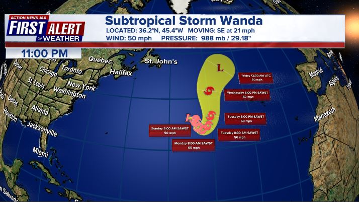
The last name on this season’s Atlantic list has now been used. A combination of a bunch of short term storms this year (8 were “alive” for less than 48 hours) + “non-conventional” (quick to pull the trigger, in other words) manner in which NHC now names storms has led to the 3rd year (2005 & 2020) in which all names have been used up. Wanda will be a “fish storm” in the truest sense ..... as in “A Fish Called Wanda” (??).
As expected, the nontropical low pressure (was the Nor’easter last week offshore of New England) separated from its frontal systems & became subtropical (not a pure warm core storm) last Saturday... then purely tropical .... while meandering over the Central/North Atlantic. There will be no impact to land areas. A transition to post-tropical should occur again over the weekend into early next week as Wanda gets picked up by the next trough of low pressure accelerating the system to the northeast over the far N. Atlantic from Sunday into Monday.
Meanwhile.... low pressure is developing near Fl. through Saturday & will intensify while moving northeast east of the U.S. east coast. Some subtropical characteristics will be possible - especially while in close proximity to the Gulf Stream over the weekend. There will be an increase in rip currents at area beaches + rough seas & surf as well as heavy rain over Fl. & parts of the Southeast U.S. coast along with strong & gusty winds. I would not be surprised to see an eye-like feature emerge over the weekend in association with this low pressure area.


South Florida Water Management District:


Otherwise.... there are signs that a fall upper level weather pattern is taking hold across the N. Hemisphere & Atlantic Basin. The result may be that the Atlantic tropical season is seriously winding down. Any tropical development will likely be more out to sea over the broad Atlantic with a tendency to move east & northeast away from the U.S.


Nov. is the last month of the Atlantic hurricane season. Tropical cyclone origins during the month:


Saharan dust. Dry air - yellow/orange/red/pink. Widespread dust is indicative of dry air that can impede the development of tropical cyclones. However, sometimes “wanna’ be” waves will just wait until they get to the other side of the plume then try to develop if everything else happens to be favorable. In my personal opinion, way too much is made about the presence of Saharan dust & how it relates to tropical cyclones.

2021 names..... “Wanda” was the last name on the Atlantic list (names are picked at random by the World Meteorological Organization... repeat every 6 years... historic storms are retired [Florence & Michael in ’18... Dorian in ’19 & Laura, Eta & Iota in ‘20]). “Adria” is next. Last year - 2020 - had a record 30 named storms. The WMO decided - beginning this year - that the Greek alphabet will be no longer used & instead there will be a supplemental list of names if the first list is exhausted (has only happened three times - 2005 & 2020 & 2021). The naming of tropical cyclones began on a consistent basis in 1953. More on the history of naming tropical cyclones * here *.


East Atlantic:


Mid & upper level wind shear (enemy of tropical cyclones) analysis (CIMMS). The red lines indicate strong shear:

Water vapor imagery (dark blue indicates dry air):

Deep oceanic heat content over the Gulf, Caribbean & deep tropical Atlantic & remains pretty impressive late in the season from the Central/NW Caribbean into the Gulf of Mexico:

Sea surface temp. anomalies:


SE U.S. surface map:
Surface analysis centered on the tropical Atlantic:

Surface analysis of the Gulf:

Caribbean:

GFS wave forecast at 48 & 72 hours (2 & 3 days):


Atlantic Basin wave period forecast for 24, 48 & 72 hours respectively:


The East Pacific:
Tropical system to stay over the open E. Pacific into next week....


West Pacific IR satellite:

Global tropical activity:


Cox Media Group
"low" - Google News
November 05, 2021 at 07:29PM
https://ift.tt/3wjBEpG
Talking the Tropics With Mike: Low pressure developing near Florida - WOKV
"low" - Google News
https://ift.tt/2z1WHDx
Bagikan Berita Ini


0 Response to "Talking the Tropics With Mike: Low pressure developing near Florida - WOKV"
Post a Comment